Visit the official Otago Central Rail Trail site


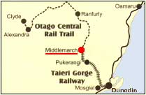
The Otago Central Rail Trail is a 150 km long former railway track which has been redeveloped for the recreational use of walkers, cyclists and horse riders. The crushed rock ballast of the railway foundation has been removed to improve the surface for users. It has over 60 redecked bridges and is a unique recreational facility within New Zealand.

Courtesy ODT 24/3/99
Courtesy ODT 25/2/00

There are two annual races: The Rail Trail Challenge and the Duathlon:

The Rail Trail Challenge (running and biking the 150km from Clyde to Middlemarch over two days) began in 2000, takes place around the last week of February, and is a Combined Lions event (Omakau, Alexandra, Maniototo and Strath lions in conjunction with Department of Conservation). See Otago Rail Trail Opening 19-20 February 2000 (programme, links, photo montage etc) and Duathlon photo montage

The Duathlon (cycling, running, cycling Ranfurly to Middlemarch) began in 1996, takes place on the last Sunday of November, and is organised by Maniototo and Strath Taieri Lions and Department of Conservation.

Looking for an organised tour? Try one of these operators: . .
.
.
.
.
.
.


  Rail Trail made easy!

Provided by
Blind Billy's


This is brochure
7 in a
series of 7*

 Middlemarch - Daisybank

Most of this material is reproduced from brochure by Otago Rail Trail Trust, October 1999

Middlemarch to Hyde:
27 km

The Rail Trail starts 400m north of the Middlemarch Railway Station. Between Middlemarch and Hyde the Rail Trail crosses the flat and gently rolling landscape of the Strath Taieri Plain. To the west the 1 400m high Rock and Pillar Range dominates the skyline; its tops accentuated by the outlines of huge rock outcrops. A characteristic cloud formation known as the "Taieri Pet" forms over the Rock and Pillar in advance of strong north west winds. East of the Taieri river is the 700m high Taieri Ridge.

The trail crosses numerous bridges and culverts of dressed local stone. The sites of three former railway stations are passed: Ngapuna, Rock and Pillar and Hyde (the Hyde Station building is privately owned). South of Hyde station the trail passes the site of the Hyde Rail accident where 21 people lost their lives in June 1943.

The trail crosses at Rock and Pillar and at Hyde. There is car parking, toilet facilities and visitor information at both Rock and Pillar and at Hyde.

(average walking speed is 4-6km/hour)

Hyde to Daisybank:
11 km

Beyond Hyde the Rail Trail leaves the open spaces of the Strath Taieri plain and enters the narrow confines of the upper Taieri Gorge. The trail closely follows the Taieri river for much of this section. Features of this part of the trail are the 152m long Price's Creek (Hyde) tunnel (bring a torch), the 32m high Price's Creek viaduct, built in 1963 to replace an earlier wooden bridge, and the historic stone bridge over the Cap Burn at Tiroiti.

The Cap Burn bridge has been retained in its original form as an example of railways engineering. The trail deviates around the bridge allowing trail users a close look at the dressed stone abutments and the iron bridge trusses. The cone shaped hills east of the river are reminders of ancient volcanic activity in this area.

An informal campsite is located midway between Tiroiti and Daisybank, adjacent to the toilet. Care must be taken with cookers (no open fires). The trail crosses again at Daisybank where there is a carpark. There is also easy access to the highway at Tiroiti.

     To the top

Facilities En Route

 
 Middlemarch
 Rock and Pillar
 Hyde
Prices Creek Tunnel  
Tiroiti


To the top

Code of Conduct
  • Share the Rail Trail with others. Move to the left when you meet other users.
  • Motorcycles and motor vehicles are not permitted on the Rail Trail.
  • Mountain bikers take special care when passing horses from behind.
  • Give way to horses on bridges. Wait until they are safely across before proceeding. Horses are to be led across bridges.
  • Leave gates as you find them and do not disturb any stock along the Rail Trail (take extra care during lambing time SeptemberOctober).
  • Always use toilets where available (toilet paper is not provided). In areas without toilets bury your waste away from waterways to the side of the Rail Trail.
  • Dogs are permitted on the Alexandra to Clyde section only and must be controlled on a lead at all times.
  • Open fires and firearms are not permitted on the Rail Trail.
  • Take all your rubbish away with you.
  • STAY ON THE RAIL TRAIL.
What to take 
  • Good walking shoes.
  • Plenty of drinking water
  • Sunscreen and a hat.
  • Warm clothes during the winter
  • Toilet paper for use in the toilets.
  • Torch for use in the tunnels.

To the top

What to expect 

The Rail Trail is similar to riding or walking on a gravel road or track. Rail Trail users may expect bumps and some loose material.

The Rail Trail provides a chance to see scenery not able to be viewed from highways and to experience a sense of remoteness and history.

Rail Trail and Children

The Rail Trail is suitable for a family experience and as such for any child who is keen on biking and uses a 16 inch bike or bigger with no trainer wheels.

The stretches between Tiroiti and Rock & Pillar do have some areas, where heavy ballast remains on the trail, and this can cause a few problems for children on smaller-wheeled bikes. As long as they are keen and encouraged, the ride is worthwhile. The gradient is fairly even all the way and therefore does not cause the problems of hill climbs.

The Rail Trail is the access way to Central Otago and share the hot summer climate. Remember sunblock and plenty of liquid (there are few watering spots along the way).

Riding is suitable all year round, except through snow. There are no sheltered points along the way yet, and on a hot day riding in the morning or late afternoon is recommended.

To the top

Origins of the Rail Trail 

150 km of the former railway line from Middlemarch to Clyde was acquired by the Department of Conservation in 1993 for redevelopment as a recreational facility for walkers, cyclists and horse riders. The former railway was renamed the Otago Central Rail Trail. The Rail Trail is modelled on Rails to Trails projects elsewhere in the world. It took 6 years of development and $850,000 to upgrade the closed railway to its current standard. Over 60 bridges, several over 1 00m in length, were redecked and have had hand rails erected to make them safe for Rail Trail users. The crushed rock ballast of the railway foundation has been removed to improve the surface for users. The Rail Trail is now a unique recreational facility within New Zealand. It has also preserved, largely intact, an important part of Otago's history.

In the days before the railway it could take two days by coach from Dunedin to reach the Central Otago towns. Goods and supplies, which had to come by wagon, took much longer as a days travel for a wagon was seldom more than 30 kilometres.

From the early 1 870s there were calls for a railway to be built to Central Otago. There was general agreement on the need for the railway but there was much argument over which route it should take. In 1877 a government report reviewed seven possible routes:

  • Kingston to Cromwell, via Frankton,
  • Waipahi to Cromwell, via Roxburgh
  • Lawrence to Cromwell, via the Clutha valley
  • North Taieri to Cromwell, via the Strath Taieri
  • Palmerston to Cromwell, via Macraes Flat
  • Palmerston to Cromwell, via Shag Valley
  • Oamaru to Cromwell, via Dansey's Pass

The Strath Taieri route was adopted because it crossed a minimum of rough country and allowed access to the largest area of Crown land available for settlement.

Construction began with a ceremony on June 7 1879. Vincent Pyke, former goldfields warden and the Member of Parliament for Dunstan, had the honour of turning the first sod in a ceremony at Wingatui, near Dunedin. Construction of the line was slow. It took 6 years to complete the first 12.5 km. It wasn't until January 1891 that the line reached Middlemarch, a distance of 64 km. The remaining 150 km of line to Clyde was opened in April 1907. Between 1914 and 1921 the line was extended to Cromwell.

Almost all the construction work (apart from bridge contracts) on the line between Middlemarch and Cromwell was carried out under a cooperative system. Under this system, workmen formed themselves into parties of 10 - 12, one of whom was elected the head man. Construction work was broken into sections and the engineer assessed the value of the work to be done on each section. The men were paid monthly; each man receiving a proportion of the total money based on the hours they worked. Construction camps were set up along the railway for the workmen and their families. Schools, stores and boarding houses were built along the line to cater to the needs of the inhabitants of the camps. These camps were periodically shifted along the line to keep pace with the construction.

Once completed the railway carried both passengers and freight. Fruit, livestock and wool were major freight items. After World War Two passenger numbers declined as private car usage increased. Up until 1961 the transporting of freight by trucks further than 48 km was prevented by government regulation to protect the railways from competition. In 1961 the restriction was relaxed to 64 km and restrictions on hauling livestock by road were entirely removed. In 1977 the limit was relaxed to 150 km and in 1983 all restrictions were removed.

Once this happened the end of the Central Otago line was certain. The line from Clyde to Cromwell was closed in 1980. Due to the construction of the Clyde dam the line to Clyde remained open through the 1980s. Construction work on the dam began to wind down in 1988 and the decision was taken to close the line in April 1990. The last train left the Clyde station on 29 April 1990. The tracks between Clyde and Middlemarch were removed during 1991. The remaining section of line from Wingatui to Middlemarch was purchased by the Dunedin City Council and is operated as a tourist venture by the .

To the top

Other brochures
available
Brochure 1 - General Rail Trail Brochure 
Brochure 2 - Clyde - Chatto Creek
Brochure 3 - Chatto Creek - Lauder
Brochure 4 - Lauder - Oturehua
Brochure 5 - Oturehua - Ranfurly
Brochure 6 - Daisy Bamk - Ranfurly
Brochure 7 - Middlemarch Daisy Bank
 Otago Rail Trail
contacts

Visit the official Otago Central Rail Trail site

The Area Manager
Department of Conservation
Coastal Otago Area

Dunedin
Phone

The Area Manager
Department of Conservation
Central Otago Area

Alexandra
Phone

The Executive Officer
Otago Rail Trail Charitable Trust

Dunedin

Go to Otago Central Rail Trail Official Opening// Horse Enduro// Duathlon

| Home | How to get here | Where to stay | What to do | History | Nature & Wildlife | Rural Life Skills Competition |